|

By Eric Boyle, Vice President, ICF
January 12, 2017
 |
 |
More than 800 million people worldwide suffer from chronic malnutrition. Changing this alarming fact requires innovative approaches built on sound evidence and a nuanced understanding of the interactions among the causes and effects of food insecurity.
International development companies play a vital role in helping donor agencies target their limited resources to help save lives and stop malnutrition. For example, CIDC member ICF’s researchers, analysts, and scientists combine disciplines and insights to help people in need, the communities they live in, and the world. From conducting baseline studies for the USAID Office of Food for Peace’s food development assistance programs in over a dozen countries to supporting performance evaluations for Feed the Future programs in Zimbabwe, ICF brings rigorous research to fuel better understanding and design better programs.
One of the keys to success is to better connect the dots, and ICF provides innovative methods of linking multiple data sources to better understand food security challenges and the needs of specific populations across the globe. Innovations include linking a range of data types such as dynamic data that change frequently (rainfall, crop growth, market prices), contextual data that change slowly over time (stunting, wealth indices, mortality rates), and access data including geographic features, such as distance to markets or tarmac roads.
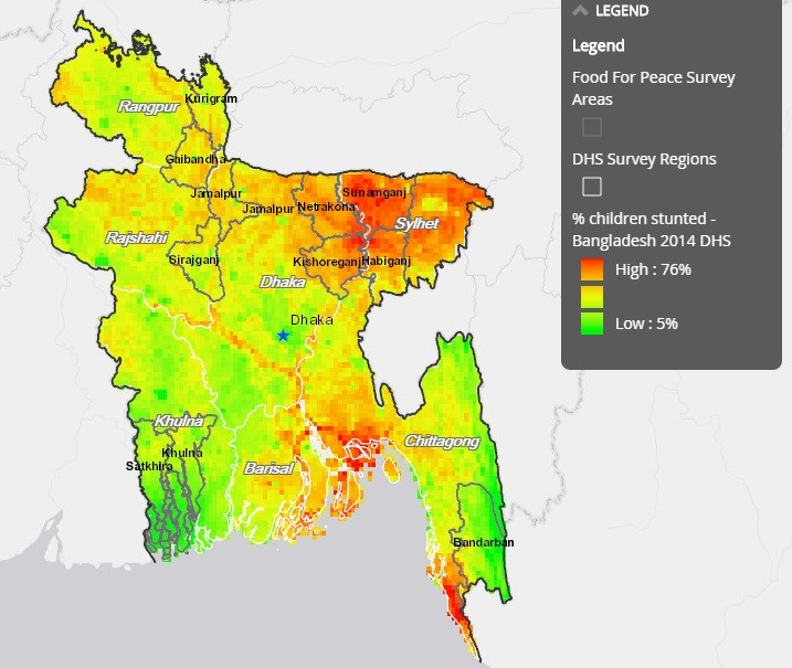
While relevant data may be available to help identify key causes of food insecurity and guide relevant programming decisions, it is often a challenge to sort through that data to make it actionable. Development companies like ICF assist donors and decision-makers to reformat data into geographies such as livelihood zones, recalculate indicators into usable formats and represent data in geospatial formats for contextual understanding – often at a granular level to ensure better targeting of resources. The map of Bangladesh demonstrates the power of linking data sources and visualization. By combining wealth quintiles of USAID’s Demographic and Health Surveys (DHS) with stunting indicators and food insecurity zones, ICF provides data to help USAID target resources even within an area as small as 5x5 kilometers. Resources and data are shared via open source platforms available for other donors and stakeholders, too.
With ever-advancing technology coupled with our unchanging passion, ICF and other international development companies help the U.S. government fulfill the promise of the 2016 Global Food Security Act to “end global poverty and hunger within our lifetimes.”
|